Monstrous super typhoon Usagi holding its own, Hong Kong braces for possible impact

Super typhoon Usagi, 2013′s strongest storm on the planet, may have peaked in intensity, but remains an extremely dangerous cyclone as it continues on a collision course with southern Taiwan and, likely, Hong Kong.
The Joint Typhoon Warning Center says Osagis maximum sustained winds are 150 mph, the equivalent of a category 4 hurricane. Thats down from at least 160 mph Thursday (category 5 level). But this is a mammoth storm, tropical storm force winds span 275 miles across it.
On Thursday evening, a satellite-based estimate of its minimum pressure was an astonishingly low 882 mb, which would have made it the deepest and most intense storm to exist on Earth since 1984 (tied with hurricane Wilma in 2005).
Look at this incredible high resolution satellite image of the storm from Thursday afternoon, revealing the textbook traits of a flawless cyclone:

You see the cloud-free, distinct eye which is surrounded by tall thunderstorms on all sides.
Due to a re-arrangement of its internal structure since that time, known as an eye-wall replacement cycle, Usagi has lost some steam and its satellite presentation while impressive is less than perfect.

Its eye is somewhat ragged, and deep convection (a fancy term for thunderstorms) is less pronounced in its northeast quadrant.
Whats next for Usagi?
The Joint Typhoon Warning Center predicts additional weakening as Usagis circulation is disrupted by Taiwan. Usagi will batter Taiwans south and east coast with damaging winds, *******ial range, massive waves, and a dangerous storm surge today into Saturday. The storms rain bands have already begun to lash coastal areas.

Usagi is then expected to cross the South China Sea, but further weakening is forecast.
THE SYSTEM IS UNLIKELY TO RE-INTENSIFY OVER THE SOUTH CHINA SEA DUE TO LAND INTERACTION AND DECREASING OCEAN HEAT CONTENT, says the Joint Typhoon Warning Center.

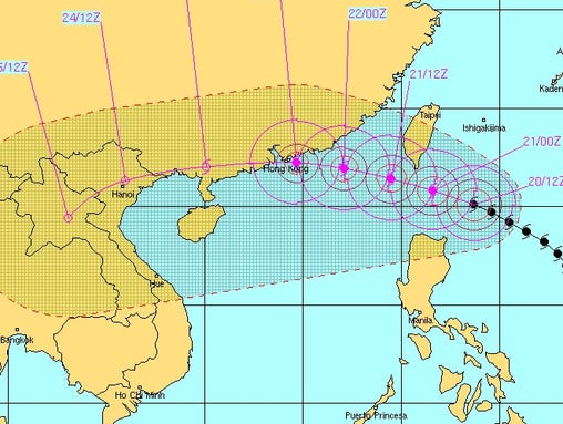
The storm could potentially come ashore near Hong Kong late Sunday local time (Sunday morning EDT). Confidence in the overall track is high but small deviations could push the brunt of the storm to Hong Kongs northeast or southwest.
Usagi is still far away from Hong Kong, writes the Hong Kong Observatory. As there may still be changes to its track, its effects on Hong Kongs weather can be vastly different. Usagi is a mature tropical cyclone and may become the strongest storm affecting Hong Kong since this year. The public should remain vigilant, pay attention to the latest weather report, and take precautions against strong winds and flooding as early as possible.
The Joint Typhoon Warning Center predicts Usagi will have maximum sustained winds near 100 mph around the time it would potentially make landfall in or near Hong Kong. If a direct hit were to occur, the storm would also produce copious amounts of rain and, depending on the angle of approach, potentially a devastating storm surge (given the storms size and intensity).
This is a very busy weekend in Hong Kong, as a major autumn festival is underway.
Quote:
|
Originally posted by @EricHolthaus
.@HeathaT says #Usagi's arrival in Hong Kong would be bad timing (mid-Autumn fest). 'Like having a typhoon hit NYC on Thanksgiving weekend."
|
------------------------------
Powerful typhoon hits Taiwan, Philippines
TAIPEI, Taiwan (AP) The most powerful typhoon of the year swept through the Luzon Strait separating the Philippines and Taiwan on Saturday, battering island communities and dumping rain as it eyes landfall in Hong Kong.
Super Typhoon Usagi had maximum sustained winds of 139 mph and gusts exceeding 163 mph Saturday morning, and was 550 kilometers south of Taipei, Taiwan's capital, according to the U.S. Navy's Joint Typhoon Warning Center. A storm achieves super typhoon status when winds reach 150 mph.
Taiwan's Central Weather Bureau said later Saturday that Usagi was veering west, likely sparing southern Taiwan from the most destructive winds near its eye.
But gusts exceeding 144 mph were recorded on the Taiwan island of Lanyu, and the bureau warned that dangerous winds were buffeting the holiday resort of Kending on the Hengchun peninsula as the storm makes its closest approach to the area.
In the Philippines, Usagi triggered landslides and power outages in parts of the north of the country, including the Batanes island group where it made landfall early Saturday. No casualties have been reported.
The government's weather bureau warned that storm surges and heavy waves could cause damage in the Batanes and other islands in the Luzon Strait before Usagi blows past the Philippines on Saturday night.
China's National Meteorological Center announced a red alert, its highest level, as the storm maintained its track toward Hong Kong and the manufacturing heartland of the Pearl River Delta. The observatory warned Usagi will impact coastal areas of Guangdong, Zhejiang and Fujian provinces.
The U.S. Navy's warning center predicted that Usagi will approach Hong Kong with weaker but dangerous sustained winds of 110 mph early Monday morning, while the Hong Kong Observatory hoisted the No. 1 Standby Signal and warned the storm poses a "severe threat" to the city.
In Taiwan, nearly 2,500 people were evacuated from flood-prone areas and remote mountainous regions as the government deployed military personnel into potential disaster zones. The storm system has dumped more than 8 inches along the eastern and southern coasts in a 13-hour period, with officials warning that a total rainfall of 39 inches could drop before the storm leaves Sunday.
Local officials closed mountain highways blocked by landslides and suspended train services connecting the east and west coasts as power outages affected thousands of homes.
Usagi retains a massive diameter of 680 miles, with its outer rain bands extending across the main northern Philippine island of Luzon and all of Taiwan across to the Chinese coast. Taiwan's Central Weather Bureau warned winds of 63 mph could hit Taipei.
The Office of Civil Defense in Manila said landslides damaged houses and roads, and pockets of power outages were reported in at least five northern provinces, where several roads and bridges were impassable.
Cathay Pacific Airways and Dragonair said flights Saturday were unaffected except for one canceled flight, but both airlines warned of delays and cancelations at Hong Kong International Airport from Sunday evening to Monday morning, and urged passengers to postpone non-essential travel on those two days.


 i think that was 4 years ago. What kind of scary prediction


